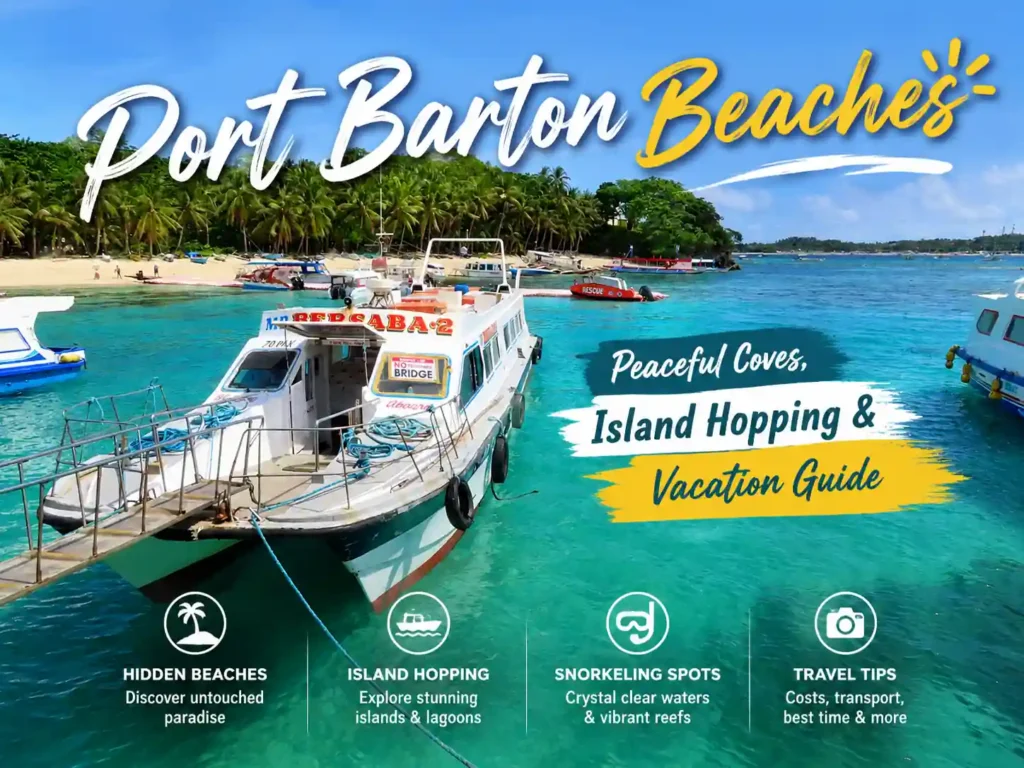

Port Barton beaches are, without question, some of the most underrated coastlines in the entire Philippines. While El Nido pulls all the Instagram traffic and Puerto Princesa fills up tour buses year-round, Port Barton beaches sit quietly between them, cleaner, calmer, and far more honest about what a true tropical escape should feel like. The moment you arrive, something shifts. The crowds thin out. The water gets impossibly blue. The pace of everything slows down in the best possible way.
Located in the municipality of San Vicente in northern Palawan, Port Barton sits within the Coral Triangle, the global center of marine biodiversity, covering 6 million square kilometers of ocean and home to 76% of the world’s coral species, according to the World Wildlife Fund. That geographic positioning is not just a talking point. It directly explains why every beach, reef, and island in this area looks like it was designed to make you stop moving and just stare.
This guide covers every significant beach and island worth visiting in Port Barton, with practical information on how to get there, what to expect, and how to make the most of every day on the water.
Why Port Barton Is Famous for Hidden Beaches
Port Barton sits roughly midway between El Nido (95 km north) and Puerto Princesa (165 km south), which historically kept it off the major tourist trail. That geographic isolation is precisely why the beaches here stayed intact for so long.
The Philippine Tourism Authority (PTA) classifies Port Barton as an ecotourism destination under the National Ecotourism Strategy, which limits commercial development within the shoreline buffer zone. As a result, no large resorts have been allowed to carve up the beachfront, and most accommodation in the area remains small guesthouses, bamboo cottages, and family-run properties.
The result is a coastal environment that still feels real.
Port Barton beaches also benefit from the Sulu Sea on the west, which delivers warm, consistently clear water with visibility depths often reaching 20 to 25 meters on calm days, conditions confirmed by PADI-certified dive operators working in the area. The sea surface temperature averages between 28°C and 30°C throughout most of the year, making every beach visit comfortable regardless of season.
What makes Port Barton beaches different from El Nido? (Quick Answer )
Port Barton beaches have fewer crowds, lower prices, and more accessible snorkeling directly from the shore or via short boat rides. El Nido is more commercialized and tour-dependent. Port Barton is better suited for independent travelers who want genuine quiet.
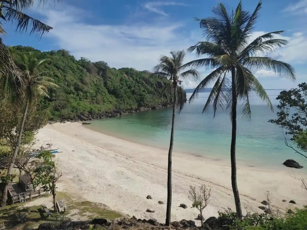
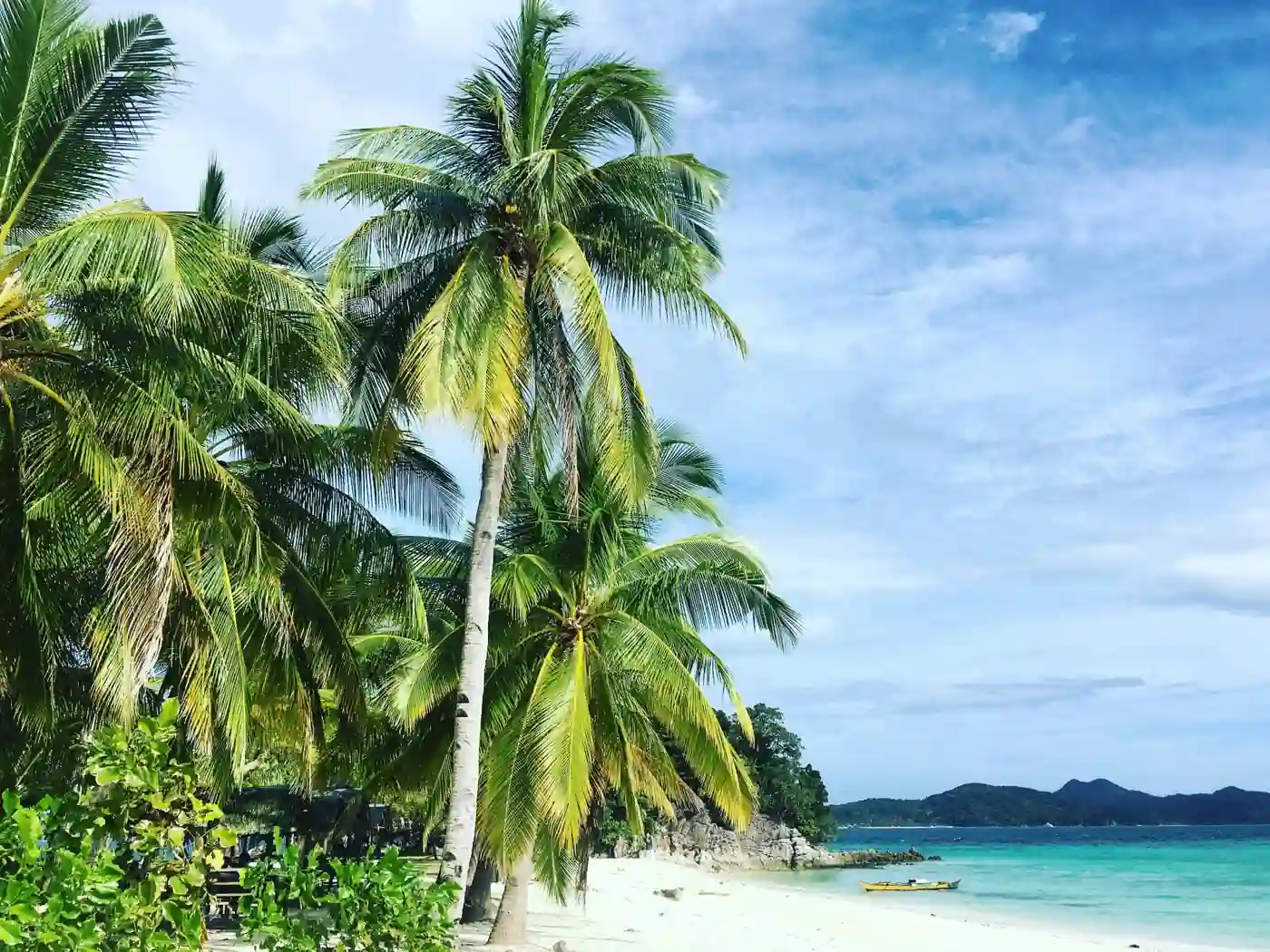
White Beach: The Most Popular Relaxing Spot
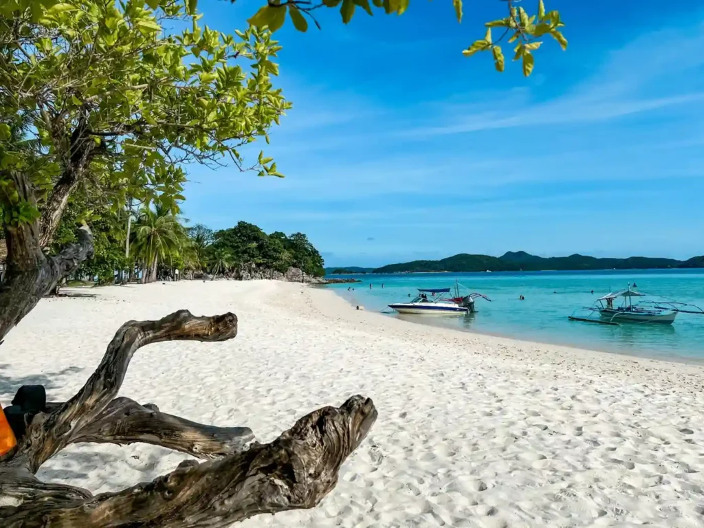
White Beach is the main beach in the Port Barton village, and the first one most travelers see. It runs for approximately 600 meters along the waterfront, with powdery sand and shallow, calm entry into the sea. The beach is lined with small restaurants, hammocks, and rental shops, none of them overwhelming.
The water here is best in the morning. By midday, the light flattens, and visibility drops slightly, but it never becomes murky. Snorkeling just 50 meters out from the shoreline reveals decent coral coverage, particularly around the rocky outcrops on the southern end.
White Beach at Port Barton is the social hub of the entire area. Travelers gather here in the evening for food, and most island-hopping tours depart from the outrigger boats anchored just offshore.
Key facts:
- Best time to swim: 6:00 AM – 10:00 AM
- Snorkeling quality: Moderate (best at the southern rocky section)
- Facilities: Restaurants, sun loungers, kayak rentals, tour booking
Want to experience nightlife in Port Barton like a traveler, not a tourist? Here are the bars, food spots, and beach hangouts locals actually recommend.
German Island Beach, Snorkeling Paradise
German Island is a 20-minute boat ride from the Port Barton main beach and consistently rated as the best snorkeling location in the entire area. The reef surrounding the island is part of a protected marine sanctuary managed by the local government unit (LGU) of San Vicente, established under Municipal Ordinance No. 09-2018.
The coral here is genuinely healthy. Hard and soft coral formations in shades of orange, purple, and white are visible in less than two meters of water. Reef fish diversity is significant; butterflyfish, parrotfish, clownfish, and schools of sergeant majors are standard sightings. Green sea turtles have also been recorded here by local guides, though sightings are not guaranteed.
What makes German Island stand out among Port Barton beaches is the shallow lagoon on its northern side. The entry is easy for non-swimmers, the current is almost nonexistent, and the visibility is consistently 15+ meters.
| Feature | German Island | White Beach | Exotic Island |
| Snorkeling Quality | Excellent | Moderate | Very Good |
| Coral Health | High | Low–Moderate | Good |
| Crowd Level | Low–Moderate | Moderate–High | Low |
| Distance from Port Barton | 20 min by boat | On-shore | 35 min by boat |
| Sea Turtle Sightings | Occasional | Rare | Rare |
| Suitable for Non-Swimmers | Yes (lagoon) | Yes | Partially |
Exotic Island Beach, Crystal Clear Waters
Exotic Island lives up to its name more than most beaches in the Philippines dare to. The water is the kind of clear that looks edited in photos but genuinely isn’t. You can see the sandy bottom clearly at a depth of three meters, and the gradient from white sand to turquoise to deep blue happens within 20 meters of shore.
The beach itself is small, maybe 150 meters end to end, with a dense coconut grove providing shade through most of the morning. There are no permanent structures here. Just the beach, a few wooden picnic tables maintained by the island-hopping cooperative, and the reef offshore.
Exotic Island is also notable for a reason most visitors don’t think about: it sits on the edge of a migratory route used by spinner dolphins, and local boat operators occasionally encounter them between Exotic Island and the next stop on the standard island-hopping circuit. There’s no guarantee, but it happens often enough that guides mention it as a realistic possibility.
I’ve spoken with two experienced local boatmen who’ve worked Port Barton beaches for over a decade, and both pointed to Exotic Island as the spot they’d go to personally if they had a free afternoon.
Coconut Beach, Quiet and Scenic Escape
Coconut Beach sits on a small peninsula about 25 minutes north of Port Barton’s main jetty. It’s shaded almost entirely by mature coconut palms that lean out over the water at sharp angles, giving the beach a distinct cinematic quality that photographers tend to go wild over.
The beach is accessible by boat or, if you’re feeling adventurous, by a 45-minute hike through light jungle from the road. The hike is not difficult, but the path gets slippery in wet conditions; proper footwear matters.
What Coconut Beach is best for:
- Hammock relaxation under natural shade
- Peaceful afternoon swimming
- Photography, particularly during late afternoon golden hour
- Complete disconnection from tourist infrastructure
Swimming conditions are calm and safe through most of the year, though the beach faces west and can get choppy during stronger northwest winds in December and January.
Pamuayan Beach, Hidden Gem Near the Jungle
Pamuayan Beach is the hardest to reach among the well-known Port Barton beaches, which is exactly why it still feels undiscovered. Getting here requires a longer boat ride, roughly 45 minutes from the main village, or a guided hike through the secondary forest that backs up against the shoreline.
The forest connection is what makes Pamuayan genuinely unusual. The beach is situated directly at the edge of a protected watershed area that forms part of the Palawan Biosphere Reserve, designated by UNESCO in 1990. At low tide, a freshwater stream meets the sea at the southern end of the beach, creating a natural mixing zone that supports a unique micro-ecosystem not typically found on pure marine beaches.
Birdwatchers in particular find Pamuayan worth the effort. The forest fringe is home to several endemic Palawan species, including the Palawan hornbill (Anthracoceros marchei) and the Palawan peacock-pheasant (Polyplectron napoleonis), both listed as vulnerable on the IUCN Red List.
Pamuayan is one of the Port Barton beaches, where arriving by boat at sunrise genuinely justifies the early alarm.
Long Beach Port Barton, Peaceful Shoreline Walk
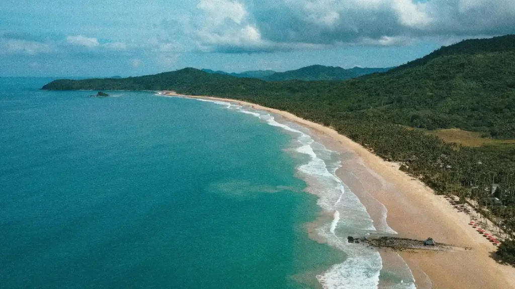
Long Beach, technically located in the San Vicente municipality, sits at the northern edge of what’s commonly considered the Port Barton area. At 14.7 kilometers, it is one of the longest unbroken white-sand beaches in the Philippines, surpassing even some sections of Boracay’s famous coast.
The northern stretch near Port Barton is largely undeveloped, though development pressure is increasing from the south, where resort projects have been approved under the San Vicente Tourism Master Plan (2022–2032).
Walking the beach at low tide takes about 3 hours end to end. Most travelers don’t make the full walk; they arrive by tricycle or motorcycle rental from the main road and spend a few hours at a specific stretch before heading back.
The sand quality is exceptional. Fine, white, and cool underfoot even in direct sun. The beach faces west, making it one of the best sunset-watching locations among all Port Barton beaches; the horizon is completely clear of islands, giving a full, unobstructed view.
Starfish Island Beach, Best for Marine Life
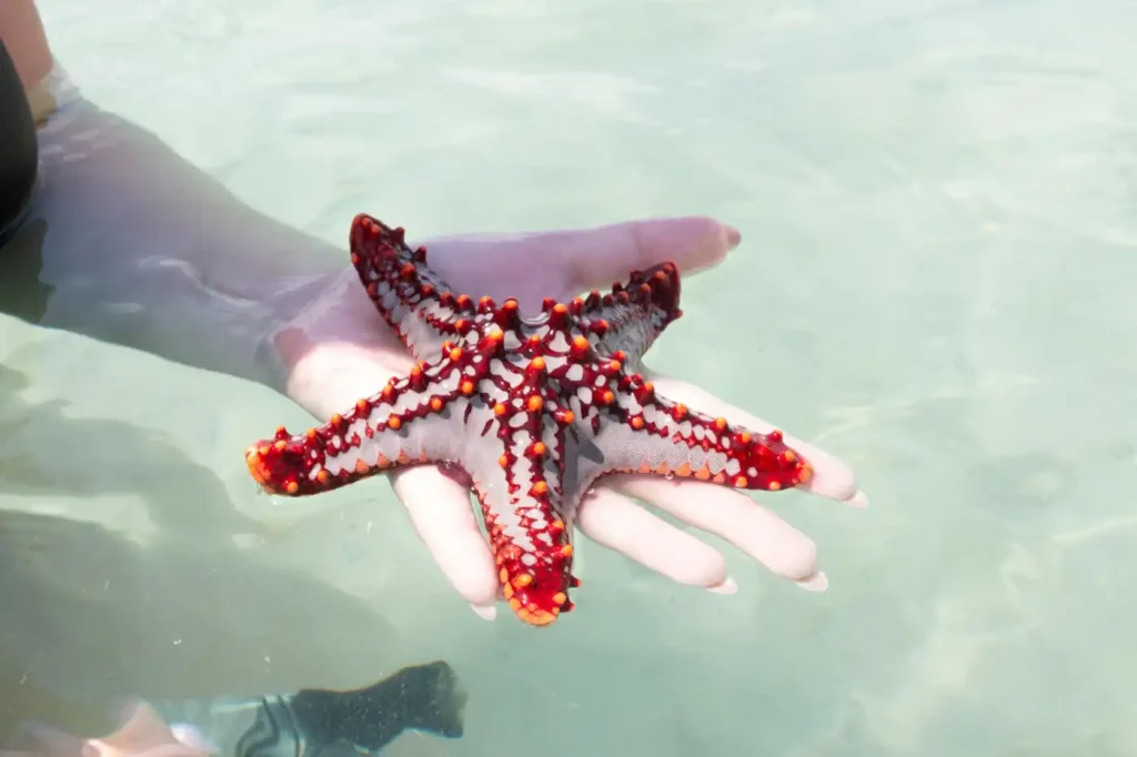
Starfish Island is exactly what the name promises. The sandy shallows around the island are home to large numbers of cushion sea stars (Culcita novaeguineae), visible clearly in knee-deep water without snorkeling gear.
Important note: Philippine law (Republic Act No. 8550, the Fisheries Code) prohibits collecting, removing, or harming any marine species, including starfish. Reputable tour operators in Port Barton enforce this rule, and the LGU of San Vicente has placed visible signage on the island.
The beach itself is small and often busy during peak season because of its novelty factor. If you’re visiting Port Barton beaches primarily for snorkeling or swimming, Starfish Island is a quick stop rather than a destination; 20 to 30 minutes is usually enough.
Starfish Island is best for:
- Families with young children (shallow, calm water)
- First-time snorkelers
- Quick photo opportunities
- Marine biology enthusiasts
Naonao Beach; Off-the-Beaten-Path Beauty
Naonao Beach is the kind of place that doesn’t appear on most Port Barton beaches itineraries, which makes finding it feel like a genuine discovery. The beach is accessible only by private boat; there’s no road, no official trail, and no permanent structure of any kind.
The reef system off Naonao is arguably more intact than any other spot in the Port Barton circuit. Local dive guides describe it as showing less bleaching damage compared to nearby reefs, likely due to minimal foot traffic and its deeper shelf structure that buffers against temperature extremes.
First-time visitors often underestimate how remote Naonao actually is. There’s no shade infrastructure, no freshwater source, and no cell signal. You bring what you need and take everything back. That’s also what makes it perfect.
Naonao is a full-day commitment, best paired with Pamuayan or German Island on a longer custom tour rather than a standard day circuit.
The Overlooked Economics of Port Barton’s Tourism Model
Most guides praise Port Barton’s “untouched” beaches without explaining why. Beyond policy and geography, a key reason is the local fishing cooperative. The Port Barton Fisherfolk Association runs most island-hopping tours, controls pricing, rotates island access, and sets environmental rules. This creates a natural limit on daily visitors, giving beaches regular rest days. It’s an informal sustainability system that has protected Port Barton better than many fast-developing Southeast Asian destinations, but if outside operators or unchecked growth weaken it, the beaches could change dramatically within a decade.
Tips for Visiting Port Barton Beaches
Practical details that actually matter:
- Cash only. There are no ATMs in Port Barton village. The nearest reliable ATM is in Roxas, about 60 km away. Bring enough cash for your entire stay.
- Island hopping prices are set by the cooperative and range from ₱500 to ₱1,200 per person, depending on the circuit. Private boat hire runs ₱2,500 to ₱4,500 per day.
- Bring your own snorkel gear if possible. Rental equipment in Port Barton beaches is available but inconsistent in quality.
- Reef-safe sunscreen is encouraged by local guides and increasingly enforced on cooperative-managed islands. Chemical sunscreens containing oxybenzone are banned in many Palawan marine areas under DENR Administrative Order 2021-16.
- Plastic policy: The municipality of San Vicente has a single-use plastic ban in force. Carry a reusable bottle.
| Island Hopping Circuit | Beaches/Islands Covered | Duration | Avg. Price (per person) |
| Standard Circuit A | White Beach, German Island, Starfish Island, Exotic Island | 6–7 hours | ₱600–₱800 |
| Extended Circuit B | Above + Coconut Beach + Naonao Beach | 8–9 hours | ₱1,000–₱1,200 |
| Custom Private Tour | Any combination | Flexible | ₱2,500–₱4,500/boat |
| Snorkeling Focus Tour | German Island, Exotic Island, reef sites | 5–6 hours | ₱700–₱900 |
Best Time to Explore Port Barton Beaches
Port Barton sits on the west coast of Palawan, which means its weather pattern is the inverse of the Philippine mainstream. The dry season runs from November to May, with the clearest skies and calmest seas between January and April.
| Month | Sea Condition | Rainfall | Visibility | Crowd Level |
| Jan – Feb | Calm, mild NW wind | Low | 18–25m | Low–Moderate |
| Mar – Apr | Flat calm | Very low | 20–25m | Moderate (peak) |
| May | Calm, warming | Low | 18–22m | Moderate |
| Jun – Aug | Choppy, some storm days | High | 8–15m | Low |
| Sep – Oct | Variable, improving | Moderate | 12–18m | Very Low |
| Nov – Dec | Calm, cooling | Low–Moderate | 15–20m | Low–Moderate |
The sweet spot for Port Barton beaches is March to May, with ideal sea conditions, high visibility, and manageable crowds before the Holy Week rush. February is also excellent for travelers who prefer even quieter conditions.
Avoid June through September unless you’re comfortable with weather uncertainty. Many boat operators in Port Barton suspend or limit island hopping during the strong southwest monsoon (habagat) season due to wave height restrictions set by the Philippine Coast Guard.
Final Thoughts on Port Barton Beach Hopping
Port Barton beaches are not perfect. The infrastructure is basic, the road in is rough, and the lack of ATMs catches almost every first-time visitor off guard. But none of that actually matters once you’re out on the water.
What Port Barton offers, across White Beach, German Island, Exotic Island, Coconut Beach, Pamuayan, Long Beach, Starfish Island, and Naonao, is something increasingly rare in Southeast Asian travel: coastal beauty that hasn’t been managed into something corporate. The reef is still alive. The water is still clear. The local guides actually know these places because they’ve spent their lives on them, not because they were trained by a resort company last month.
Every major beach guide, from Lonely Planet’s Philippines edition to Condé Nast Traveler’s Southeast Asia features, has started to include Port Barton in its recommendations over the past three years. That recognition is deserved, but it also signals that a clock is ticking. The best version of Port Barton beaches exists right now.
Frequently Asked Questions
Q1: How do I get to Port Barton from Puerto Princesa?
From Puerto Princesa, take a van or shared minibus to the Port Barton junction in San Vicente, journey time is approximately 3.5 to 4.5 hours. Vans depart from the San Jose Terminal near the public market. From the junction, a tricycle covers the final 7 km to the village. Total travel time from Puerto Princesa airport is around 5 hours.
Q2: Are Port Barton beaches safe for swimming?
Yes. Most Port Barton beaches are safe for swimming year-round during the dry season (November to May). During the wet season (June to October), wave conditions can make some beaches unsuitable. Always ask local boat operators about current sea conditions before heading out.
Q3: Is Port Barton better than El Nido?
It depends on what you’re looking for. Port Barton beaches are less crowded, more affordable, and better suited for relaxed, independent travel. El Nido has more dramatic limestone formations and a more developed tourism infrastructure. Budget travelers and those seeking quiet usually prefer Port Barton.
Q4: How many days do you need in Port Barton?
Most travelers need 3 to 4 days minimum to cover the main Port Barton beaches and complete at least one full island-hopping circuit. Five to six days allows for a slower pace and time to visit Pamuayan and Naonao on a separate day trip.
Q5: Is there WiFi or mobile signal in Port Barton?
Mobile signal (Globe and Smart networks) is available in the main village, but weak and inconsistent. Some guesthouses offer WiFi, but speeds are generally slow. Most travelers treat Port Barton as a digital detox zone rather than a remote work destination.
Q6: What is the best beach in Port Barton for snorkeling?
German Island consistently offers the best snorkeling conditions among all Port Barton beaches, with healthy coral coverage, good visibility, and calm entry conditions accessible even for beginners.