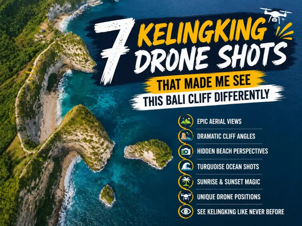

If you’ve been scrolling through Instagram and suddenly stopped at a photo of a T. rex-shaped cliff hanging over turquoise water, that’s Kelingking Beach, Nusa Penida, Bali. And yes, kelingking drone shots are every bit as dramatic as they look.
I flew my DJI Mini 3 Pro here in August 2023, and honestly, I wasn’t prepared for how the whole place would feel from above. The cliff just… reveals itself differently at altitude. Getting the right kelingking drone shots takes some real planning, though. The wind, the tourists, the rules, all of it matters more than people think.
Why Kelingking Drone Shots Look So Unique
The limestone peninsula juts out into the Indian Ocean like a natural sculpture. From ground level, you can see it’s stunning. But from 80 meters up, the scale hits completely differently, the jade-green water wrapping the base of the cliff, the white sand beach almost unreachable below, and the jagged ridgeline stretching toward the horizon.
According to Nusa Penida Tourism Board data from 2023, Kelingking attracted over 400,000 visitors that year, making it the most photographed natural site on the island. No surprise there. The T. rex head formation, technically a sea stack connected to the main cliff, creates a natural frame that’s nearly impossible to replicate anywhere else on earth.
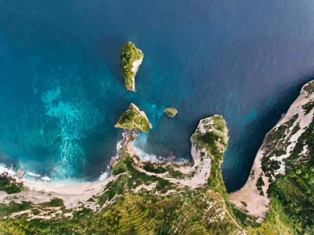
What makes the aerial angle special is contrast. Blue against white against green, with the rust-orange rock. It’s genuinely one of those spots where even average footage looks cinematic.
What Makes Kelingking Beach So Stunning from above; Read more in Kelingking Beach Guide: I Almost Turned Back on Bali’s Famous T-Rex Hike.
Best Time to Capture Kelingking Drone Shots
Golden hour is the obvious answer, but let me be more specific because timing here is actually tricky.
- Sunrise (5:45–7:00 AM): Soft side-lighting, almost zero wind, very few tourists. This is the best window.
- Late afternoon (4:30–6:00 PM): Warm tones but wind picks up significantly after 3 PM from the southwest.
- Midday: Harsh light flattens the cliff texture. Avoid for cinematic work.
- Avoid Fridays and weekends: Foot traffic near the viewpoint increases drone interference risk.
A local guide named Made Suarsana, who’s been taking photographers to Kelingking since 2018, told me that September and October offer the clearest skies and calmest morning conditions. The rainy season (November–March) brings dramatic clouds but also unpredictable gusts that can push a drone sideways fast.
Here’s a quick timing breakdown to plan your shoot:
| Time | Light Quality | Wind Level | Crowd Level |
| 5:45–7:00 AM | Soft golden / blue hour | Very low | Minimal |
| 7:00–10:00 AM | Clean morning light | Low–moderate | Low–moderate |
| 10:00 AM–3:00 PM | Harsh, flat overhead | Moderate | High |
| 3:00–5:00 PM | Warm but windy | High | High |
| 5:00–6:30 PM | Golden sunset tones | Very high | Moderate |
Top Drone Angles at Kelingking Beach
There’s no single right way to shoot this place, but a few angles consistently produce the most stunning results. Here are the three I keep coming back to:
Classic Cliff Edge Perspective
Launch from the main viewpoint parking area and fly directly out over the cliff edge, keeping the camera angled down at about 45 degrees. As you push forward, the T-Rex head appears below you. This shot at around 60–80 meters altitude gives you that full scale shot where you can see the entire peninsula, beach, and ocean in one frame.
Pro tip: fly slowly on your outward path. At around 70 meters out from shore, pause and take a burst. That’s usually where the cliff-to-ocean ratio looks best.
Kelingking Drone Shots From the T-Rex Viewpoint
This is the angle that gets the most viral traction on social media. Position your drone about 120 meters out from the cliff face and at roughly sea level height, or just slightly above the T-Rex formation (around 40 meters). Then tilt the camera up slightly to capture the full head shape against the sky. These types of kelingking drone shots look absolutely surreal when the water behind the formation is deep blue.
I nearly lost my drone here when a sudden gust from the southwest pushed it sideways. Always fly with sport mode OFF at this location, the auto-corrections are too aggressive on a gusty day.
Wide Ocean Frame
Pull back to around 200 meters and gain altitude to 100+ meters. Turn the camera to face the full coastline. This gives you a wide establishing shot, cliff on one side, open ocean stretching to the horizon. At 4K/30fps with a neutral ND16 filter, you’ll get silky water motion if you stay hovering for 15–20 seconds.
Drone Rules and Flying Restrictions at Kelingking
Indonesia’s drone regulations fall under Permenhub No. 47 of 2016 (Ministry of Transportation). For recreational drones under 250g like the DJI Mini series, registration is not required. However, drones between 250g–7kg need to be registered with the Directorate General of Civil Aviation (DGCA).
- Always stay below 120 meters (400 feet) above ground level.
- Do not fly within 5 km of Ngurah Rai International Airport, Nusa Penida is outside this radius, so you’re clear.
- No commercial flights without proper permits from the Indonesian Civil Aviation Authority.
- Private land and national park areas may have separate restrictions, always ask local guides.
- No flying over crowds of people without insurance and permits.
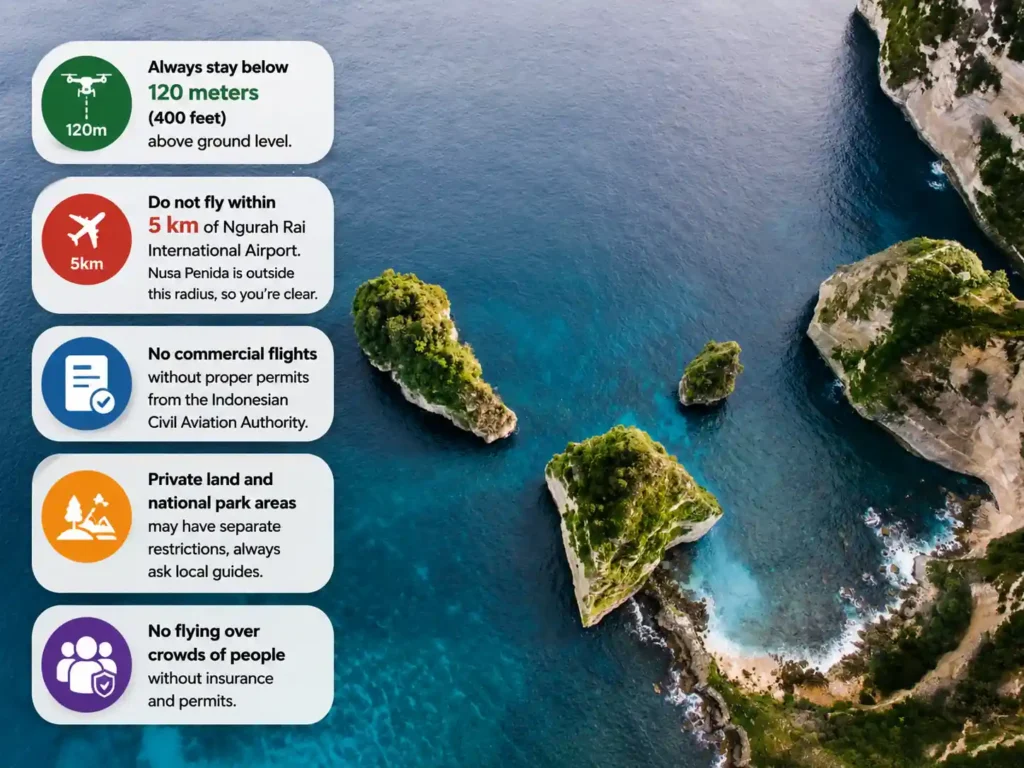
In practice, local enforcement at Kelingking is minimal, but that doesn’t mean the rules don’t apply. A few drones have been confiscated at other spots in Bali. Don’t be that person.
Drone weight categories and their requirements in Indonesia:
| Drone Weight | Registration Required | Pilot License | Notes |
| Under 250g (e.g. DJI Mini 3) | No | No | Most visitor-friendly option |
| 250g – 2kg (e.g., DJI Air 3) | Yes – DGCA | No | Register before flying |
| 2kg – 7kg (e.g., DJI Mavic 3) | Yes – DGCA | Recommended | Commercial use needs a permit |
| Over 7kg | Yes + special permit | Required | Professional operators only |
Camera Settings for Better Aerial Results
Settings matter a lot here. The ocean reflects a massive amount of light, and without the right setup, you’ll blow out the highlights completely.
- Use ND16 or ND64 filter depending on time of day, ND16 for morning, ND64 for full sun.
- Set shutter speed to 2x your frame rate (60fps = 1/120s shutter).
- ISO: stay under 400 for the cleanest footage. Push to 800 max in shade.
- Use D-Log M or a flat color profile if your drone supports it, which gives more dynamic range in post.
- White balance: fixed at 5500K for golden hour, 6200K for midday.
- Resolution: 4K at 30fps is the sweet spot. 60fps for slow-motion passes.
What Is the Best Altitude for Kelingking Drone Shots?
The best altitude for Kelingking drone shots is between 60 and 100 meters above the viewpoint. At this height, you capture the full T. rex cliff formation, the white sand beach below, and the surrounding turquoise ocean. Going higher than 100 meters flattens the depth. Going lower than 40 meters risks losing sight of the full peninsula shape.
Common Mistakes to Avoid When Filming Kelingking
Everyone makes at least one of these the first time. Hopefully you won’t:
- Flying too high, too fast, you lose the dramatic scale of the cliff.
- Shooting at midday without ND filters, blown highlights ruin the footage.
- Ignoring wind direction, the peninsula creates turbulent air on the west side in the afternoon.
- Forgetting to check battery life before flying over the cliff, it’s a long way down to nothing.
- Flying too close to other tourists near the viewpoint causes tension and can draw attention from authorities.
Weather Conditions That Affect Drone Footage
Nusa Penida’s weather can shift fast. The dry season (May–September) is generally the safest for flying, with consistent morning calm windows. The wet season brings dramatic skies but also sudden squalls.
According to Bali Meteorology, Climatology and Geophysics Agency (BMKG) data, average wind speeds at Nusa Penida between June and August are around 10–15 km/h in the morning, climbing to 25–35 km/h by mid-afternoon. That’s the difference between a smooth, stabilized shot and a shaky mess.
Monthly flying conditions at Kelingking, a practical reference:
| Month | Season | Morning Wind | Visibility | Recommended? |
| Jan–Feb | Wet | Gusty | Variable | No |
| Mar–Apr | Transition | Moderate | Good | Possible |
| May–Jun | Dry | Low | Excellent | Yes |
| Jul–Sep | Dry peak | Very low | Crystal clear | Best window |
| Oct–Nov | Transition | Moderate | Good | Yes, cautiously |
| Dec | Wet | Gusty | Variable | No |
What Drone Is Best for Kelingking Beach?
The DJI Mini 3 Pro is the most recommended drone for Kelingking Beach. It weighs under 249g (no registration needed in Indonesia), has excellent stabilization in moderate wind, supports 4K/60fps video, and has a 34-minute battery life. The DJI Air 3 is a strong alternative for serious videographers who want wider dynamic range and dual cameras.
Safety Tips Before Launching Your Drone
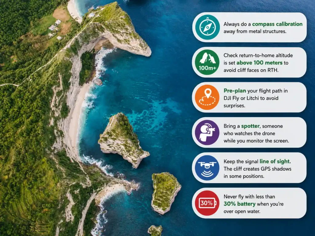
This section is short but genuinely important. Kelingking is not a flat field; you’re launching near a 300-meter cliff edge.
- Always do a compass calibration away from metal structures.
- Check return-to-home altitude is set above 100 meters to avoid cliff faces on RTH.
- Pre-plan your flight path in DJI Fly or Litchi to avoid surprises.
- Bring a spotter, someone who watches the drone while you monitor the screen.
- Keep the signal line of sight. The cliff creates GPS shadows in some positions.
- Never fly with less than 30% battery when you’re over open water.
Can You Fly a Drone at Kelingking Beach Legally?
Yes, you can fly a drone at Kelingking Beach legally if your drone weighs under 250g (like the DJI Mini series), you stay below 120 meters altitude, and you avoid flying over crowds. Drones over 250g must be registered with Indonesia’s DGCA. There is currently no designated no-fly zone at Kelingking Beach as of 2024, but local regulations can change, so always check with your accommodation or a local guide before flying.
Final Thoughts on Getting the Best Kelingking Drone Shots
Kelingking is one of those spots that genuinely earns its reputation. Not every famous Instagram location does. But this cliff, this particular slice of Nusa Penida, is legitimately extraordinary from the air.
The best kelingking drone shots come from patience more than gear. Show up early. Wait for the wind to settle. Fly slow. Let the place reveal itself on your monitor. You won’t regret the early alarm.
And if it doesn’t work out the first morning? Come back. Made told me some photographers return four or five times before they get the perfect light. That’s just how it goes with drone photography in the real world.
FAQs: Kelingking Drone Shots
Q1: Do I need a permit to fly a drone at Kelingking Beach?
If your drone weighs under 250g, no permit is required for recreational use in Indonesia. Drones between 250g and 7kg need DGCA registration. Always confirm current rules with your resort or a local guide before flying.
Q2: What is the best drone for Kelingking?
The DJI Mini 3 Pro is the most practical choice for most travelers, lightweight, powerful, and under the registration threshold. For professionals wanting higher image quality, the DJI Mavic 3 Classic offers a Hasselblad sensor but requires registration.
Q3: Is it windy at Kelingking Beach?
Yes, especially in the afternoon. Mornings between 5:45 and 9:00 AM typically offer the calmest conditions. Wind speeds can exceed 30 km/h by 3 PM, which makes drone flying difficult and risky.
Q4: Can I fly my drone during the dry season only?
The dry season (May–September) is strongly recommended. Flying is technically possible year-round, but the wet season (November–March) brings unpredictable gusts, low visibility, and sudden rain that can damage electronics.
Q5: What altitude gives the best Kelingking cliff footage?
Between 60 and 100 meters is the sweet spot. This height captures the full T. rex formation, the beach below, and the ocean context. Lower feels cramped; higher loses the cliff’s dramatic scale.
Q6: Are there any restricted areas near Kelingking for drones?
There is no formal no-fly zone at Kelingking as of 2024. However, the east side of Nusa Penida near Toyapakeh has some restricted airspace near the harbor. Always check NOTAM updates on the AirMap or DJI Fly app before you fly anywhere in Indonesia.